Excerpted from The Everyday Life of Memorials by Andrew M. Shanken, published by Zone Books. Copyright © 2022 by Andrew M. Shanken. Reprinted by permission.
[W]here memorials have landed is as invented as modern memorials themselves. In addition to cemeteries and parks, they are commonly erected in front of civic buildings and appear where street patterns leave spare spaces. This stands to reason: these are the principal public spaces in towns and cities. They are also spaces where institutions border on and push back against the market, or, just as frequently, where capitalism’s claims are weaker, those places of noncommercial transaction, the urban leftovers that improvers of cities sought to beautify. Such habits of placement are curious because these sites of commemoration collide with landscapes that serve some other purpose or no official purpose at all. When memorials have no intrinsic relationship to their site, it changes their meaning and frees them to interact with their context differently. This could be insidious, as when towns in the American South placed Confederate monuments in front of courthouses to bolster racist ideology with the false authority of the law. The sculpted soldier on his high plinth, sometimes with gun in hand, standing in front of hall of judgment, planted a grave warning in places pushing to roll back the freedoms of Black people in the South. Even when the place of memorials is more innocent or expedient, it is still saturated with significance.
Most commemorative interventions are geographically arbitrary. Their place in the world is as bound by convention as their form. The Maos, Bismarcks, Stalins, Husseins, and other eminences, as well as allegories of Peace and Independence and many war memorials erected by zealous committees, or autocrats, often have an ulterior relationship to their place. Yet as the last chapter explored, even the most modest war memorials placed in cemeteries and churchyards or on village greens were novel interventions. They introduced mnemonics in places that rarely had served as sites of public commemoration. Much like parks and cemeteries, these sites were the spatial equivalents of neologisms — neotopisms — in their own right and undergoing rapid change under the pressures of urbanization. To place memorials required new rationales. New conventions needed to be established on the fly. As much as memory in popular lore is rooted in place, many memorials are curiously ageographical. People have had to find a place for them in the context of these changes.
The “great men” on their pedestals are not the only monuments that seem out of place. An extreme example sets the edge of the inquiry, links up with the tradition of memorials in parks, and leads to the less charted urban fragments that are the subject of this chapter. The Holocaust Memorial in Miami Beach, like all American Holocaust memorials, cannot mark a site of the Holocaust in any literal way. Although it marks the tragic diaspora of the Shoah, it is ageographical. For such a sober subject, the setting is all-important, but it is also incongruous. It lies beside the Miami Beach Convention Center and its massive parking lot, adjacent to the Miami Beach Golf Club and the city’s Garden Club, in a largely commercial area with busy, multilane streets fronting two sides of the site. This unusually large parcel was converted into a parklike setting designed especially for the statue. Yet to call it a park is misleading. Unlike the sort of urban parks discussed in the last chapter, the Holocaust Memorial takes over the entire space, making it a Holocaust park, an absurd proposition.
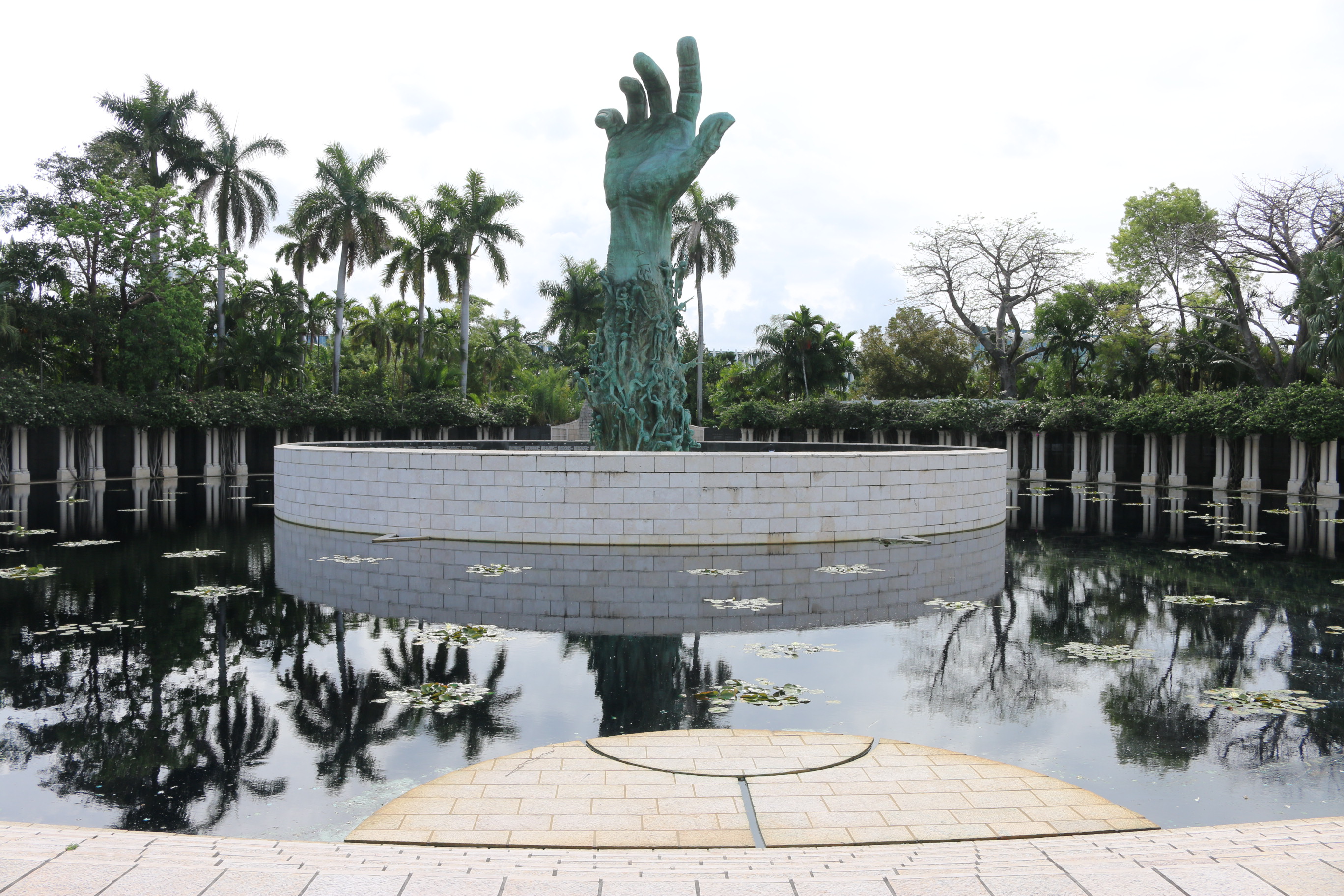
Miami Beach, Florida. Photograph by the author. Image provided by the Princeton University Press.
Such a placement, such a concept, requires a justification, an argument. That argument is the Holocaust itself. The reasons in Miami Beach are not obscure. When Jewish survivors in Miami met in 1984 to discuss building a memorial, Miami Beach was seen as a fitting location because it had such a high number of survivors, some twenty to twenty-five thousand at the time. Nonetheless, considerable opposition arose and converged on issues of place.1 Miami Beach was “a place of sun and fun,” one Garden Club member, Florence Shubim, proclaimed: “Gloom is doom! Don’t turn one of the city’s few bright spots into a cemetery.” Little did she know her comment condensed a century of debate about the place of memorials in American culture, with many parallels to similar debates around the world. The memorial was to take up a city-owned plot that the neighboring Garden Club had eyed for expansion. Advocates for the memorial prevailed, but not before they observed a more mystical justification for the site: the physical address was 1933–1945 Meridian Avenue, the numbers corresponding to the years of the Third Reich, leading “many to believe that the Memorial was bashert,” or fate, which also swayed city legislators.2
The memorial’s location required an argument, because aside from the numerological happenstance of the address, it lacked an intrinsic relationship to its site. The “park” was necessary to make a clear separation from the ordinary urban tissue that surrounded it, but it also created a jarring juxtaposition with the memorial itself. The landscape lulls one into the contemplative, leisurely, escapist — and, yes, elegiac — mood that modern parks are meant to evoke, made all the more so by the noncommemorative garden it abuts. This is what made parks likely places to deposit memorials in the first place. They were antidotes to the workaday world of the city. Force of habit has made this convention seem natural. But the monumental bronze limb in Miami Beach is so clearly not natural that it lays bare the forced convention.
Memorials in churchyards, cemeteries, and parks at least found a dignified public place and could tap into religious or civic traditions, however recent or changeful. By contrast, many memorials have found their way onto what Mariana Griswold Van Rensselaer called the “little squares and open corners where, alone or in combination with trees and shrubs, monuments of one sort or another are eminently appropriate.”3 Van Rensselaer’s writing on the subject, which at times could sound like an etiquette guide for statues, was really about the beautification of these “left-over or cut-off pieces of land often found at street convergings.”4 These urban crumbs posed nettlesome problems for cities. Such remnants often came under the jurisdiction of the park authorities that came into existence beginning in the late nineteenth century. This was a bit of municipal wishful thinking. Most of the locations were anything but pastoral, but their aspirational assignment as parks confesses a desire to recast the city, in whatever morsels could be found, into something more parklike. Rus in urbe. Toward the end of the century, major cities began forming art commissions to handle the contentious business of placing memorials.5 These new municipal authorities, in turn, had to work with one of the most crucial, if mundane, problems cities faced: traffic. Memorials began to appear in medians, traffic circles and roundabouts, or along great boulevards and in prominent squares. These habits surely derived from France, or Europe more broadly, the source of so many American conventions, but they also learned from the wider elegiac tradition that had been central to the reconciliation of death through its propitious placement.6
Many conventions of placement are easy to understand, at least superficially. Place transforms memorials, which acquire meaning through context, adjacency, and commemorative practices. Cemeteries at least are places of death; churches have long hosted graveyards and are places of piety (as well as sites for the reenactment of the central death of Christianity); and parks are places of reflection. Even traffic circles are nodes of heightened attention, as can be piazzas and civic buildings, when they offer public space for official commemorations. The “entrances” to towns offer a prominent site for monuments to do their most traditional work of moral admonition or exemplification. They are all eminently practical sites, as well, being public, available, and usually free of the need to use eminent domain to purchase the land. Yet each of these sites is also far more complicated. Each changed in order to become a realm of memory. In turn, modern memorials acquired their meaning in relationship to these various places.
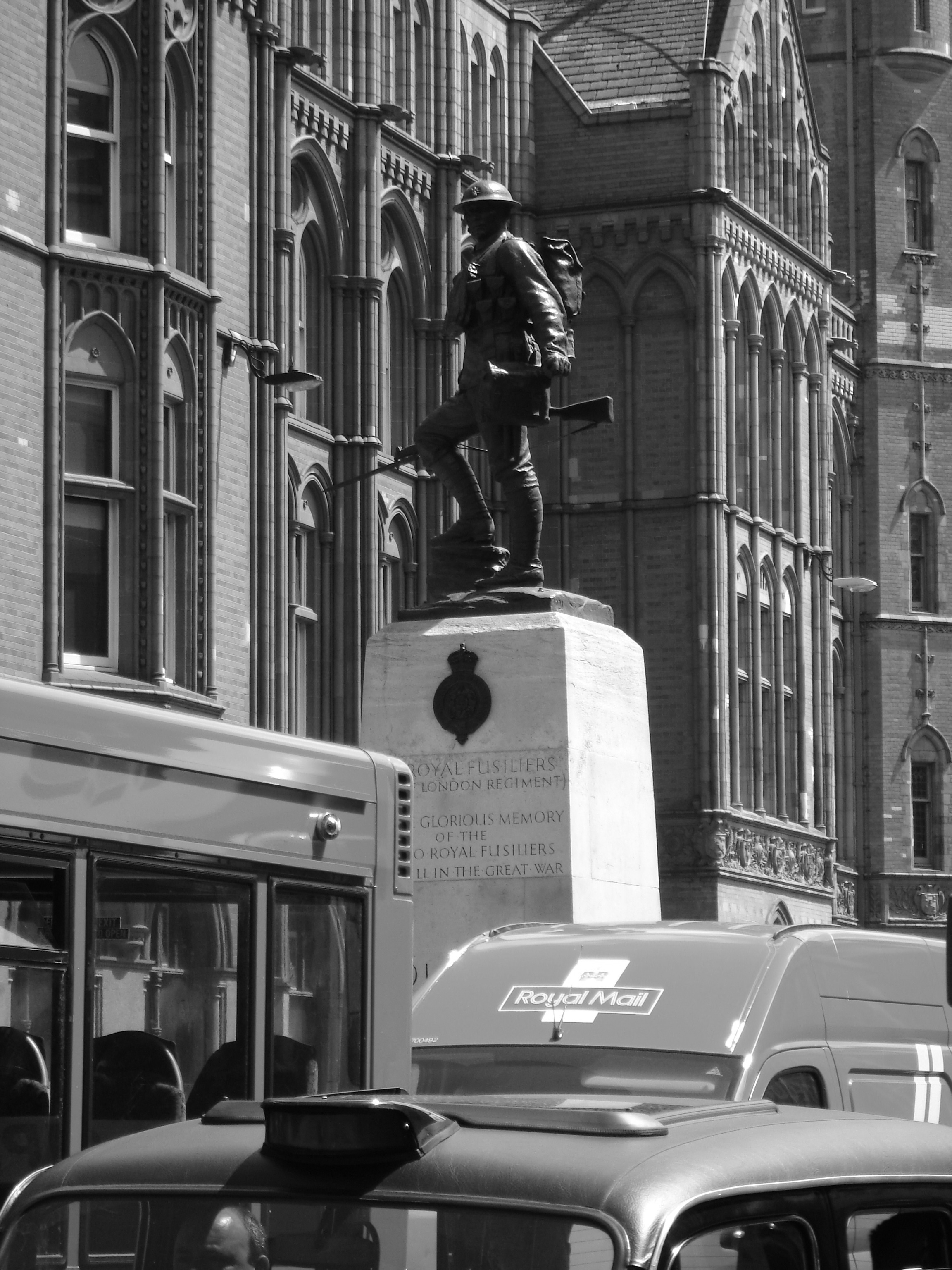
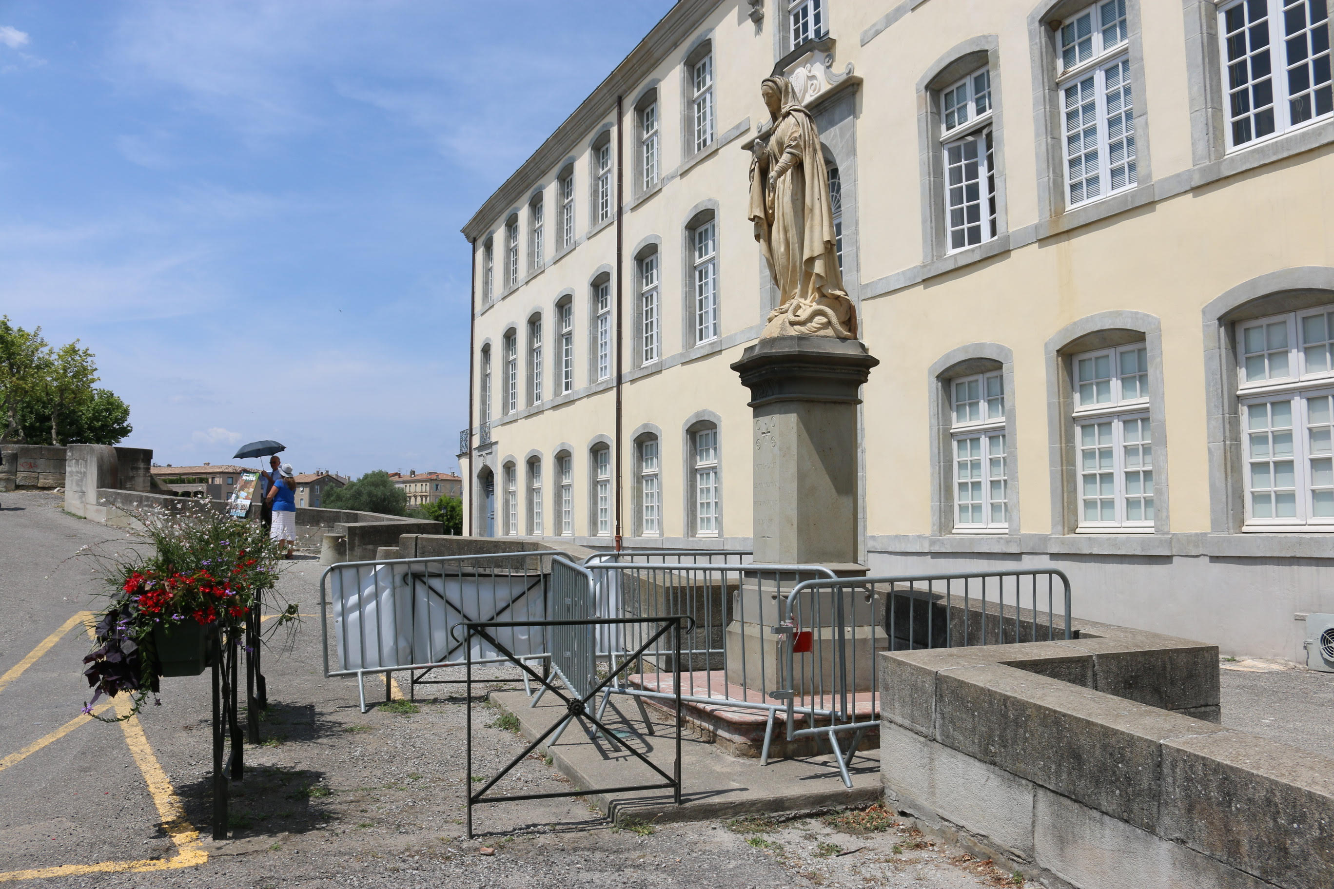
At their worst, public monuments appear to have been thrown to the cars. The Royal Fusiliers Memorial on High Holborn in London (1922) is the urban equivalent of sticking something in the attic. It is difficult to fathom an artful reason for its placement. Without shutting down the street, it affords no place for commemorations and offers no good purchase from near or far for pedestrians to take it in. To encounter it up close, to read its inscription or gaze at the statue atop, would have been a hazard even in 1922. The obvious prototype in terms of placement, Edwin Lutyens’s Cenotaph, built in London just two years earlier, had several distinct advantages: it was beautifully designed by a major architect, and it was sited on Whitehall, a generous boulevard that served as the major parade route for Remembrance Day in Britain.7 From the end of World War I, when a temporary cenotaph by Lutyens was erected there, the street was closed to traffic for these commemorations.8 The Royal Fusiliers Memorial, by contrast, is undistinguished, its site unforgiving. The most that one can say by way of a sympathetic reading is that there was a long history in Europe of erecting crosses and other quasi-commemorative monuments at major crossroads and byways, where their very location was meant to disrupt, to redirect the mind from the mundane to the spiritual realm. Throughout Europe, statues of religious figures punctuate urban pivots, as does the Virgin lamenting her railings in Carcassonne, France, built in the era of statuemania (1861). In fact, it appeared just after the castle was restored, turning the site into a major tourist attraction. The Virgin was erected at the foot of the bridge between the town and the castle, where she greeted this new secular stream of traffic. Although she was set discreetly next to a religious institution, she is now so conspicuously misplaced that the permanent railings proved inadequate, and a ghastly tangle of guardrails was added to fence her off. The inscription reads: “Notre-dame de Consolation priez pour nous” (Our Lady of Consolation prays for you). Just don’t get too close. The Royal Fusiliers Memorial may have been placed with similar intentions and to induce a similar interaction, only to be engulfed by a faster and more relentless urbanism than could not have been foreseen in 1922.
The Virgin looks increasingly out of place in a secular world, but there is one perspective from which the London memorial works remarkably well: the best way to get close, it turns out, is in a bus stuck in traffic, preferably a British double-decker bus.9 Here, in its most quotidian moment, blocked by a big red bus, the memorial gives an intimate audience to its elevated passersby paused there by the pulse of traffic. At 16.5 feet high, the pedestal lifts the bronze soldier, who is another 8.5 feet tall, just above bus eye level, where he still stands heroically. The uppermost inscription, however, is what our imagined commuter would see when she looks up from her Daily Mail or Guardian: “To the glorious memory of the 22,000 Royal Fusiliers who fell in the Great War.” The new breed of memorial that celebrated the everyday soldier was often tossed into the most ordinary of places, and the unintended result is an extraordinary encounter.10
Since every city has its urban fragments, this is an international phenomenon. A more complicated example, the Mexican-American All Wars Memorial (1949) in Boyle Heights, Los Angeles, inhabits a “leftover” in the Mexican-American neighborhood of Cinco Puntos. Here, two grids converge, and five roads cross, leaving two triangles on which a series of related memorials have been installed. The site is quintessentially ordinary. A well-known Mexican restaurant sits astride the site, a Mexican supermarket across the street. Residential neighborhoods spread out to the north and south, and the impermeable wall of Evergreen Cemetery (discussed in the previouschapter) abuts the site, as well. Cesar Chavez Avenue, the historic core of the Mexican-American community, cuts through the site; in fact, the memorial interventions spill across the intersection onto the second island. Even the memorial landscape is cut by a street! The site reflects the community’s desire to commemorate the over-looked military contributions of Mexican-Americans, but it also demonstrates just how little public space and power they had at their disposal.
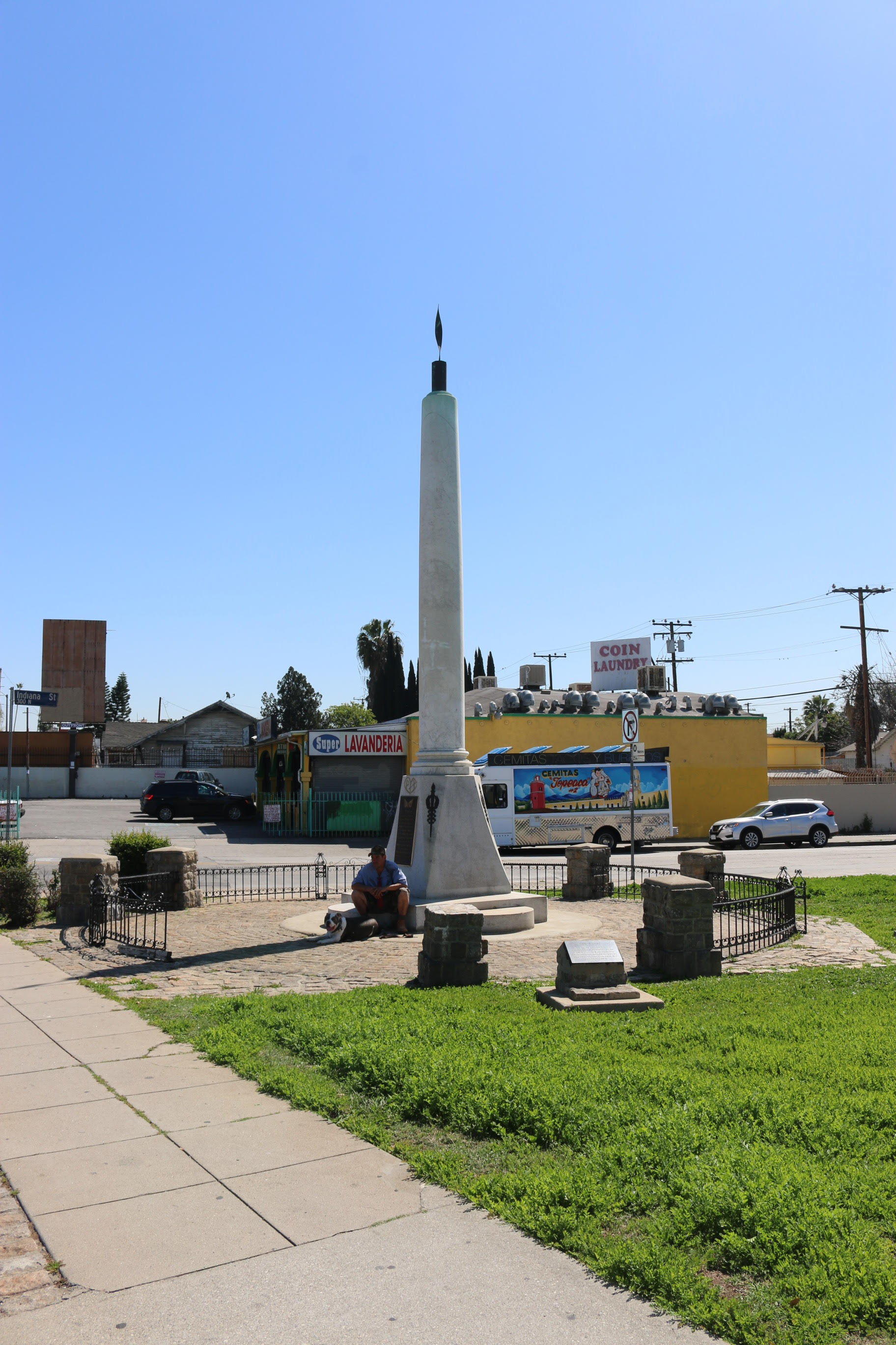
Its quasi-official status—it is maintained primarily by local businesses, high school groups, and veterans associations—is exacerbated by the fact that the intersection divides two distinct planning authorities.11 Neither the Los Angeles Department of City Planning, which oversees Boyle Heights, nor the Los Angeles County Department of Regional Planning, which oversees unincorporated East Los Angeles, claims responsibility for the site. In fifty years of urban plans for Boyle Heights, nothing about Cinco Puntos has changed on official maps, which don’t even show the memorial.12 Community initiatives in the 1970s with far greater sensitivity to local heritage also neglected the memorial and its site.13 While plans were drawn up by the Los Angeles Department of Transportation in 2014 to place the memorial in a traffic circle — where else! — in order to highlight it better, the area clearly has low priority.14
Placing the obelisk here was a matter of local pride, but it landed here as much by default as by design. Unlike the Japanese-American community that had been in the area for generations, in 1949, the Mexican-American community did not have a long history in the adjacent Evergreen Cemetery. There were precious few parks or civic spaces in the area. What is now a liability — Cinco Puntos’s ambiguous jurisdiction — was an asset after the war because it allowed the community to work around official channels. The site also enables the memorial to be easily turned on and off. In anticipation of Veterans Day each year, locals clean up the memorial and stage the area with chairs and other temporary structures. Veterans stand for a twenty-four-hour vigil, keeping the memorial turned on.15 The rest of the year, it provides a sliver of shade and a resting spot for locals. The entire affair is a vernacular memorial with official ambitions. As Boyle Heights faces gentrification, Cinco Puntos will likely be absorbed into L.A.’s formal planning schemes, and if the Mexican-American community is displaced, the memorial could become a more generic landmark—or be moved.
The desire to formalize the Cinco Puntos memorial with a traffic circle is now a reflex, a habit in urban planning with a history that goes back nearly to premodern Europe. Traffic circles quickly became a standard way of creating order and reconciling cars and public monuments at the turn of the century, both in modest intersections in small towns and in grand urban planning and beautification schemes in the world’s largest cities. In 1904, William Phelps Eno, an American pioneer in traffic design, planned the circular flow of traffic around New York’s Columbus Monument (erected in 1892) and its pendant on the east corner of the park, where the angel first led Sherman in a traffic circle. In Paris, Eugène Hénard girdled the much earlier Arc de Triomphe in the Place d’Étoile in 1907.
Early photographs of Columbus Circle show the space chock-a-block with streetcars, automobiles, and pedestrians. In one image, a woman pushes a baby carriage across tracks while streetcars come and go and automobiles jockey with pedestrians for right of way.16 It is nothing like the present circle, with its careful segregation of pedestrians and cars synchronized by traffic lights. Such circles had roots in the rond-points of early modern landscape design, where multiple allées or paths converged in a park. Hénard and American planners knew the many rond-points of the Parisian parks well. In fact, in the mid-nineteenth century, Olmsted and Vaux imagined a kind of rond-point at the Merchants’ Gate in the southwest corner of Central Park, where Columbus Circle would eventually land.17 This circle softened the corner of the park, tied together the paths and roads that met there, and helped along the transition between park and city. The traffic circles, then, were an extension of the park system into the city, and the monuments placed in them were similar in spirit to those placed at entrances of parks. These techniques of park design beat back the hard-edged urbanism of the period. In New York City, the parks commissioner controlled the placement of monuments in these remaindered spaces.18
While Eno’s and Hénard’s circles are often seen as the first ones, distant precedents in New Orleans and Indianapolis dimly reflect baroque traditions. In 1877, New Orleans dedicated Lee Place within Tivoli Circle, an older circus that linked uptown and downtown New Orleans. The word “circle” links back to “circus” — as in Piccadilly Circus — a word that came into use for urban settings in the early eighteenth century.19 In New Orleans, a column with a bronze of Robert E. Lee atop was erected in 1884, and the area became known informally as Lee Circle. The still grander Monument Circle in Indianapolis is anchored by the Soldiers and Sailors Monument, a massive Civil War memorial finished in 1902.20 As in New Orleans, the circle predated the monument. It had been set aside as Governor’s Circle in the original speculative plan of Indianapolis of 1821. In keeping with the Midwestern habit, the green became the main public space of the city and was renamed Circle Park in 1867. A statue of Indiana Governor Oliver P. Morton went up in 1884, soon to be displaced by the Civil War monument, planning for which began in the 1880s.21
The circles in New Orleans and Indianapolis were important civic spaces transformed by their memorials. In Indianapolis, in particular, a complex public space came to be dominated by the memorial and by traffic, as if these were the twin poles of modern civic experience. Both circles have served as icons for their respective cities, appearing in guidebooks and on postcards. Both have been major sites of commemoration. Fifteen thousand people attended the dedication in Indianapolis, and thousands of people have commemorated the Lost Cause in Lee Circle.22 In the wave of protest against anti-Black racism that swept through American cities in 2017, New Orleans removed Lee and plans to replace him with a fountain. George Burnap is grinning in his grave. (See Chapter 3.) While many Confederate monuments will be disarmed in museums or “disappeared” into warehouses, “Lee Circle” will surely survive in local parlance for generations. Circles resist iconoclasm better than statues; words can be even more durable.
It did not take long for the monument in the circle to become formalized, with monuments conceived as integrated parts of larger urban schemes. A series of them punctuate the colossal axis of the Paseo de la Reforma in Mexico City. Conceived at the turn of the century, they are staged chronologically as a narrative of the history of Mexico. Inspired by Haussmann’s Paris, this is the “grand manner” at its most ambitious, cosmopolitan, and imperial in scale. Some of the monuments sit on agoraphobia-inducing public spaces. Others, such as the much later Monument to Cuitláhuac, are wedged in supermedians between busy streets, accessible only by hard-edged pedestrian bridges. This string of monuments has been seen as a form of conquest, a “path of power” and a “representation of the course of the nation towards supreme order and progress.”23 The monuments speak to the desire of the state to shape the world, or at least to shape consciousness. But they are also locked into the mundane, if also aggressively monumental, infrastructure of everyday life.